
For years, Guelph has been its own thing when it comes to our political identity. We’re a single-tier municipality, and as a federal and provincial riding out city limits have also been our electoral boundaries. But now Guelph has to learn to share. The Federal Electoral Boundaries Commission for Ontario is recommending that among the changes to the electoral map, Guelph must now be split along the south end.
“After considering the views of the public and objections by members of the House of Commons, the Commission submitted its final report to the Chief Electoral Officer for transmission to the Speaker of the House. The report was tabled in the House of Commons yesterday,” said a statement from the Commission released Thursday afternoon.
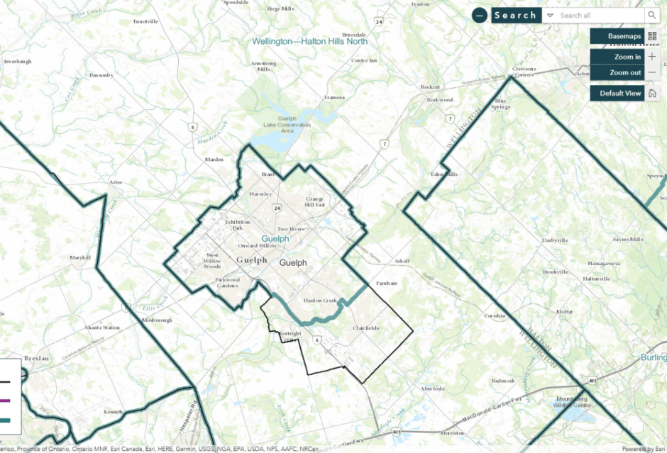
As you can seeing the map above, the city will be split south of Arkell Road in the east and then through Preservation Park south of the subdivisions on the west side of Gordon to the Hanlon Expressway. All of Guelph that’s on the west side of the Hanlon south of College Avenue will also be a part of the new “Wellington-Halton Hills North” where south Guelph will join much of the current Wellington-Halton Hills riding.
You can see a close-up of the border through the south end that now separates “Guelph” and “Wellington-Halton Hills North” below:

These new boundaries are slightly altered from the ones that the Commission revealed last fall. During a town hall about the proposed changes in September, Ward 6 Councillor Dominique O’Rourke, whose ward is almost now entirely a part of a new federal riding, took time off the campaign trail to express her concerns.
“I’m concerned that residents of south Guelph who fell under the proposed boundary change would become a small segment of voters in a huge geographic and largely rural riding,” said Ward 6 Councillor Dominique O’Rourke in her designation.
“While the principle of representation by population is central in our democracy, consideration also has to be given a community of interest; the challenges in Minto, Erin and in rural townships are just not the same as those in south Guelph, which is the fastest growing part of a city that is one of the fastest growing cities in Ontario,” O’Rourke added.
Guelph MP Lloyd Longfield, who last month announced that he was not running for re-election when the current Parliament is dissolved, didn’t file any objections about the changes. Wellington-Halton Hills MP Michael Chong, however, did, but it was a note about a mistake in mapping in the Township of Guelph-Eramosa.
“Wellington-Halton Hills North” is largely unchanged from the current Wellington-Halton Hills, but along with the addition of south Guelph; portions of Halton Hills east of Acton are now part of a new riding called “Milton East—Halton Hills South.”
“In concluding this federal electoral district redistribution for the province of Ontario, the Commission wishes to express its sincere gratitude to the many members of the public who took part in this undertaking that is such an important part of Canada’s democratic process,” said the Honourable Justice Lynne C. Leitch, Chair of the Commission, in a statement.
The Chief Electoral Officer will use the new electoral boundaries in drafting the representation order, and that should make these changes official in September. The new electoral map will be used in the first general election called at least seven months thereafter.
